Monitor the Earth at multiple scales.
In real time and with many sensors.
Combine and analyse multi-sensor
satellite, aerial, and ground data.
What Makes LLcloud Special for Building
Earth Observation (EO) Applications
-
LLcloud is the new multi-sensor cloud for Earth Observation at different scales!
-
LLcloud is a platform designed and implemented specifically for multi-sensor data gathering, analysis and visualisation in the cloud.
-
LLcloud is one of the few platforms in the world which allows joint analysis of multi-sensor ground (IoT, wearable and platform), aerial (drone) and space (GPS and Galileo location and Copernicus EO) data.
-
LLcloud offers an extremely high level of automation of multi-sensor data import, conversion, organisation and processing in the cloud, thus saving considerable time and money.
-
LLcloud can be used for both data gathering from novel space and ground data solutions and applications, for design and development of downstream space data applications, but also for Living Lab trials with test users, who can then provide feedback via the same platform while testing and validating such applications.
-
LLcloud subscription plans come with a large and fast increasing collection of cloud data importers, convertors and processors for Earth Observation, IoT, wearable and smart city apps, which can be combined in many different ways.

An international team of aerospace engineers (ArteMapp) developed an affordable and practical terrain mapping solution that enables fast and frequent surveying of a selected area by walking with a mobile device. They used LLcloud for data gathering and topographical model computation and visualisation.
LLcloud has a special mobile app called photoSpot, which allows the capture of geo-located ground photos with your mobile phone, which are automatically uploaded to LLcloud. They can be combined with satellite and drone images. One of the leading smart farming University research groups in Europe uses this app and feature for monitoring plant diseases at different scales.


LLcloudFeatures for Earth Observation
Applications Include
-
Comprehensive world map search and region of interest (RoI) selection.
-
Automated download of Copernicus Sentinel data (raw or processed) from the Copernicus Data Space Ecosystem portal into LLcloud for a selected RoI (up to certain sizes and data volumes), where other multi-sensor data (ground or aerial) is already available or will be gathered, for joint analysis and visualisation.
-
Real-time tracking and movement analysis of ships (via AIS stations) and trucks (coming soon).
-
Drone images (.GeoTiff and .JPG), videos (.MP4) and flight path (.GPX) visualisation on a map. Extraction of key frames from drone videos for further exploration. Overlays of satellite and drone images for joint analysis at different scales, also with ground-based photos and other geo-located data. Integration with AirData portal for automated flightpath and telemetry data transfer to LLcloud.
-
Advanced geofences, zones, tracking, etc.
-
Communication with various IoT sensors and devices via WiFi, 5G and LoRaWAN.

Some of our clients and partners have been using Copernicus Sentinel 2 images (RGB, SWIR, NDVI, etc.) in various Earth Observation applications related to tourism, smart cities, and smart agriculture. The example shows a visible Sentinel 2 image RoI of Ilha da Armona in the Algarve, Portugal.
Едно Дърво (One Tree) is a joint initiative of landscape architects and software engineers to create interactive maps of trees in the city. LLcloud is used by their team to compare Copernicus Sentinel images of green spaces in the city to ground-based tree locations and photos to improve, speed up and scale the process of mapping and monitoring trees in cities around the world.

LLcloudIntegrations for Earth Observation
Applications Include
-
Copernicus Data Space Ecosystem integration (for access to data and services from the Copernicus Sentinel missions and more on the Earth’s land, oceans, and atmosphere) for EO from space.
-
DJI drone images, video and telemetry integration for EO from the air.
-
Global ship location and movement (via AIS stations).
-
Strava integration (for routes and location data).
-
DJI drone video and telemetry integration (coming soon) for EO from the air.
-
Capture and automated upload and organisation of geo-located and tagged photos and videos (coming soon) via the photoSpot mobile app for Android and iOS for ground-based EO.
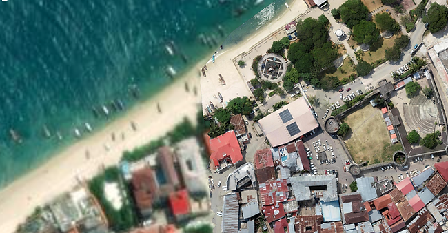
LLcloud can visualise Drone/UAV images in GeoTIFF format jointly with satellite images and other geolocated data. On the left is a UAV image by Federico Debetto, Stone Town Test, Zanzibar, DJI FC6310S, 2cm resolution, from OpenAerialMap overlaid on a visible satellite image of 10m resolution
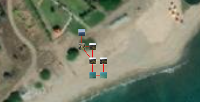
LLcloud can extract flightpath and telemetry data from DJI drone flights using the Airdata portal integration. It can extract key frames from the recorded DJI drone video at key locations and display them along the drone flight path for further inspection, as in the example to the right.
Pricing
If you are developing or testing a new EO application where you want to combine space data with ground-based (IoT/wearable) or air data and want to rapidly do this at a much lower cost, try and use LLcloud by submitting a subscription plan request.